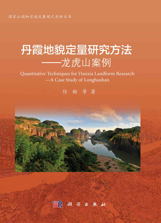
目录 序 Foreword 前言 Preface 第1章 丹霞地貌定义和龙虎山丹霞地貌简介 1 1.1 丹霞地貌名称由来与特点 1 1.1.1 丹霞地貌名称由来 1 1.1.2 丹霞地貌主要形态分类与特点 4 1.2 龙虎山区域概况 5 1.2.1 地理位置 5 1.2.2 区域构造背景 9 1.2.3 信江盆地地层特征及丹霞地貌成景地层 15 第2章 研究方法的创新与数据基本情况 23 2.1 戴维斯侵蚀循环理论及以往研究的局限性 23 2.2 推断假设与验证内容 25 2.3 应用的资料和数据 26 2.3.1 基础地质图件 26 2.3.2 遥感数据 26 2.3.3 一般方法 32 2.3.4 遥感和地理信息系统在地貌学中的应用 33 2.3.5 线性构造分析与构造地貌 34 2.4 基于数字高程模型的地貌形态学分析 35 2.4.1 用以评价丹霞地貌成因的地貌形态指数 36 2.4.2 面积-高程分析 37 2.4.3 标准化河长坡降指标(SLK)和Hack剖面 40 2.5 多源数据的预处理和集成 42 2.6 遥感图像预处理 43 2.7 基于数字高程模型(DEM)和地理信息系统(GIS)的丹霞地貌形态分析 43 2.8 野外地质调查 45 第3章 龙虎山丹霞地貌与构造控制因素 47 3.1 丹霞地貌与构造的关系 47 3.2 龙虎山地区的构造背景 50 3.3 评价方法 54 3.4 基于数字高程模型与地理信息系统的线性构造的提取 55 3.5 野外地质调查 60 3.6 分析与讨论 60 3.6.1 构造对地貌的控制 62 3.6.2 控制龙虎山丹霞地貌发育的构造动力模型解释 64 3.6.3 线性构造和裂隙分布特征 65 3.7 丹霞地貌构造控制的野外露头观测 67 3.8 线性构造特征与区域地质构造对比 70 3.9 野外剖面观测的断层运动学指标 71 3.10 结论 74 第4章 基于DEM和地貌形态指数的丹霞地貌成因分析 76 4.1 地貌形态指数在地貌学研究的作用 76 4.2 背景 77 4.3 研究资料和方法 79 4.4 基于DEM的流域盆地与水系的提取及参数 79 4.4.1 典型地貌形态特征分析 79 4.4.2 水文分析 81 4.4.3 河流纵剖面分析 90 4.4.4 岩性对标准化河长坡降指标(SLK)值的影响 100 4.4.5 断层构造对标准化河长坡降指标(SLK)值的影响 101 4.4.6 面积-高程积分曲线及面积-高程积分值 103 4.4.7 子流域面积-高程积分值分布的控制因素分析 106 4.4.8 小结 108 第5章 丹霞地貌的定量研究方法总结及相关国际比较 112 5.1 丹霞地貌定量研究方法总结及其现实意义 112 5.2 美国西部红层地貌及与中国东南部丹霞地貌的对比 114 5.2.1 美国西部红层的分布和形成年代 114 5.2.2 美国西部红层形成的地质背景 115 5.2.3 美国西部红层的岩性特征 117 5.2.4 美国西部红层地貌特征 119 5.2.5 与中国东南部丹霞地貌的对比 122 5.3 小结 124 参考文献 126 附录 Content Chapter 1 Definition of Danxia landform and brief introduction of Danxia Landform in Longhu Mountain 1 1.1 Origin and characteristics of the term of Danxia landform 1 1.1.1 Origin of the term of Danxia landform 1 1.1.2 Morphological classification and features of Danxia landform 4 1.2 Overview of Longhushan 5 1.2.1 Geographical location 5 1.2.2 Regional tectonic setting 9 1.2.3 Stratigraphic characteristics of Xinjiang Basin and landform-forming strata of Danxia landform 15 Chapter 2 Innovation of research methods and data 23 2.1 The theory of erosion cycle by W.M.Davis and limitations of previous studies 23 2.2 Inference hypothesis and verification content 25 2.3 Application Information and data 26 2.3.1 Geological map 26 2.3.2 Remote sensing data 26 2.3.3 General method 32 2.3.4 Application of remote sensing and GIS in geomorphology 33 2.3.5 linear structure analysis and tectonic geomorphology 34 2.4 Landform morphology analysis based on Digital Elevation Models 35 2.4.1 Geomorphological index for evaluating the surface process of Danxia landform 36 2.4.2 Area-Elevation Analysis 37 2.4.3 SLK and hack profile 40 2.5 Preprocessing and integration of multi-source data 42 2.6 Remote sensing image preprocessing 43 2.7 Morphological analysis of Danxia landform based on Digital Elevation Models and Geographic Information System(GIS) 43 2.8 Field geological survey 45 Chapter 3 Danxia landform and tectonic control factors of Longhushan 47 3.1 Relationship between Danxia landform and tectonic structure 47 3.2 Tectonic setting of Longhushan area 50 3.3 Evaluation method 54 3.4 Extraction of linear structure based on DEMs and GIS 55 3.5 Field geological survey 60 3.6 Analysis and discussion 60 3.6.1 Control of tectonic on landform 62 3.6.2 Interpretation of tectonic dynamic model controlling the development of Danxia Landform in Longhushan area 64 3.6.3 Linear elements and fracture distribution characteristics 65 3.7 Field outcrop observation controlled by Danxia landform structure 67 3.8 Linear element characteristics and regional geological structure correlation 70 3.9 Fault kinematic index of field observed outcrop profiles 71 3.10 Conclusion 74 Chapter 4 Genesis Analysis on Danxia landform based on DEMs and geomorphic morphology index 76 4.1 The role of geomorphic morphology index in Geomorphology Research 76 4.2 Background 77 4.3 Research materials and methods 79 4.4 Extraction and parameters of basin and water system based on DEM 79 4.4.1 Analysis on morphological characteristics of Typical Landforms 79 4.4.2 Hydrological analysis 81 4.4.3 Analysis on characteristics of river longitudinal section and bedrock erosion model 90 4.4.4 Influence of lithology on SLK 100 4.4.5 Influence of fault structure on SLK value 101 4.4.6 Strahler curve and hypometric integral(HI) 103 4.4.7 Analysis of control factors of area elevation integral value distibution in sub watershed 106 4.4.8 Summary 108 Chapter 5 Summary of quantitative research methods and Danxia-like landforms in the United States 112 5.1 Summary of quantitative research methods of Danxia landform and its practical significance 112 5.2 Development of Red Beds landforms in western United States and comparison with Danxia Landforms in southeastern China 114 5.2.1 Distribution and formation age of Red Beds in western United States 114 5.2.2 Geological background of red bed formation in western United States 115 5.2.3 Lithologic characteristics of Red Beds in western United States 117 5.2.4 Geomorphologic characteristics of Red Beds in western United States 119 5.2.5 Comparison of Red Beds landform of Zion with Danxia Landform in Southeast China 122 5.3 Summary 124 References 126 Appendix


 京公网安备 11010102004214号